The wreck of “M/V Vettor Pisani” (+1942) off Lepeda beach in Kefalonia
On 24 July 1942, the Italian motor  vessel “M/V Vettor Pisani” (built in 1939, tonnage 6,339, length 137.5m) departed from Taranto bound for Tobruk and sailing off Cape Gherogombo, the southwestern point of Kefalonia as part of a convoy, accompanied by torpedo boats “Antares” and “Calliope” and escort destroyer “Orsa”, was attacked by 6 British aircraft position 10 miles 240 degrees from said Cape 38 05N, 20 12E. See the history of the air raid here: http://aviationarchaeology.gr/?p=2249
There was an explosion, smoke and red flame.. the hit was at hold number 2 where fuel was transported in barrels and a violent fire broke out in the bow section. The severely damaged ship was towed by the “Orsa” connected by the stern, against the wind to prevent the fire from spreading to the stern section that had survived unscathed so far. Despite the efforts it was impossible to reach Argostoli harbor and in order to avoid sinking it ran aground in the shallows on the western shores of the Argostoli Gulf, specifically 1 km south of Lixouri town (pic. 1,2). It stayed ablaze until next day while a new airstrike with bombs and strafing caused even more damage. On 27 July its recovery and repair was deemed pointless and declared total loss.
Later that year, while the ship was stranded and in order to recover as much of the cargo as possible, dynamite was used to retrieve whatever could be salvaged. In photos taken from the land but also in aerial photographs of the year 1945 (Hellenic Geographical Service) the ship appears stranded (the aerial photograph also confirms the length of the ship), at a distance of approx. 300m from the coast (at the nearest point), with the bow facing southeast towards the entrance of the Gulf (pic. 3,4).
At this location the “M/V Vettor Pisani” remained until 1951 when it was refloated and towed to Italy where it was repaired to travel the seas again (fig. 5,6). Despite being destroyed by torpedoes, bombs, fire and dynamite and the long abandonment, the ship was modern enough and in relatively good condition to be left to rot, but also stranded in shallow water that could facilitate basic repairs to take it to the shipyard. Finally, after 20 years of service the ship retired in 1971 and was scraped.
The shipwreck today
What can be found today are scattered debris at a depth of only 10m, including a large number of metal barrels, batteries, parts of motorcycles, etc. all covered by sediment agglomerates. However, the most remarkable and perhaps useful for the confirmation of their destination and consequently of their origin, is a steel chain net composed of interconnected rings (pic. 7,8).
According to the “Net and boom defenses, Ordnance pamphlet 636A, 24 June 1944, U.S. Navy”, this configuration is typical for torpedo net (Type“T”net, Torpedo) (pic. 9), which were either installed in the port (suspended on floats, in a continuous barrier or partial barriers), or directly on a ship (suspended on horizontal booms, around the perimeter of the boat). The principle of operation is the following: The small cross section of a torpedo combined with its high speed exerts momentarily concentrated force on a single point, so each ring must be relatively small in diameter (about 40 cm) in order to intercept the object trying to penetrate but also attain a strong connection with the rest around it so the energy of the torpedo can be absorbed by a group of links (hence the lower end of the net was free to facilitate rotation around the horizontal axis and to diffuse the energy more efficiently). Another element of its particular usefulness was the anti-torpedo net’s ability to provide protection against aerial torpedoes, while the anti-submarine net only prevented the entry of such into an anchorage.
The above remarks make sense if we consider the destination of the ship that was Tobruk with its large natural harbour, which had just been occupied by Rommel (Deutsches Afrikakorps – DAK) a mere month ago. He was also already preparing a new offensive east into Egypt therefore this would serve him as an advanced resupply port but at the same time in close proximity to enemy naval and air forces. The Italians also had the recent traumatic experience from the raid on Taranto in November 1940, when the shortage of anti-torpedo nets (they were only 4 km installed instead of the 13 km required) led to severe damages to battleships from British aerial torpedoes.

Tilemachos Beriatos

CMAS 3 star Diver, PSS Technical Diver
Research 2012-2017

Pictures:

MV Vettor Pisani on flames

1. Vettor Pisani on flames (“Navi mercantili perdute”, Rolando Notarangelo e Gian Paolo Pagano, USMM)

Delfino in support of Vettor Pisani

2. The vessel Delfino in support of Vettor Pisani (Pietro Berti, naviearmatori.net)

Vettor Pisani grounded off the coast, Lixuri Kefalonia

3. Vettor Pisani grounded off the coast, Kefalonia (photograph Mike Georgatos)

Vettor Pisani grounded off the coast, Kefalonia aerial photograph

4. Vettor Pisani grounded off the coast, Kefalonia (aerial photographs 1945, Hellenic Geographical Service)

Vettor Pisani during repair in Monfalcone 1951

5. Vettor Pisani during repair in Monfalcone 1951 (Giorgio Parodi, naviearmatori.net)

Vettor Pisani after repair 1951

6. Vettor Pisani after repair 1951 (Ferruzzi-Venezia via Giuseppe Boato)

Metal barrels and wheels at Vettor Pisani debris field

7. Metal barrels and wheels (dive at the debris field 8-2010, Tilemachos Beriatos)

Metal torpedo net at Vettor Pisani debris field

8. Metal torpedo net (dive at the debris field 8-2010, Tilemachos Beriatos)

Rigging torpedo net (US Navy)

9. Rigging torpedo net (Bureau of Ordnance, US Navy)

Kefalonia has an amazing coastline, marine life and u/w landscape for one to discover. We may provide Guided Snorkeling by boat at Blue Manta Diving & Aquanautic Club, as certified operators, but there are lots of sites easily accessible for everyone to visit. So here are some tips or what we call “Snorkeling Paths”; some itineraries we have explored, and you can easily follow and discover the colorful u/w world.

So here are some:

  1. Mounda Beach (Skala). Enter the water where the road to Mounda ends and head left (North). The water is shallow, and rocks are the projection of the layers seen out of the water. At some point you see a small, unsealed road ending up at the seaside and putting this on your back head to some rocks rising almost up to the surface. Usually there are marked by buoys; around there you can find metal parts (look for the bathtub!) of a boat wrecked in the shallows, and on top of the rocks fragments of ancient amphora embedded on the rock. Carry on towards the tip of the cape (South) and follow the coast to return. Along your way will be seeing patches of rock and Neptune seagrass (Posidonia oceanica) – the equivalent of coral reef for Mediterranean as it supports all marine life and is a nursery for small fish and marine creatures. The site is full of schools of small black damselfish (or their neon blue juveniles!) families of graceful and colorful parrotfish, mullets and all kinds of wrasses shoals of all kinds of breams (look for the golden plated Cow breams) and …invasive spine-foots. Keep your eyes open for octopuses within the rocks and Loggerhead sea turtles in the distance.
  2. Limenia Beach (in between Skala and Poros). Enter the water at the right end of the beach, having the small dry stream on your back. Head right (South) following the coastline. At the footsteps of the rock there is Neptune seagrass (Posidonia oceanica). Damselfish, parrotfish, wrasses, breams and grey mullets are feeding on the algae and sea plants. Where there are shady holes on the rock, colorful sponges and false corals find …darkness to flourish, but you will have probably to skin dive for seeing them. However, small dusky groupers, bright red cardinal fish and moray eels stick their heads out of the shelters to watch the visitors. Most probably you will be able to spot an invasive lionfish as conditions at this site favor them. If lucky you may see a school of amberjacks sweeping the tip of the cape (especially in May and June) and if you go further around the cape and light conditions are good you may even manage seeing a broken small metal wreck that rests in a bit of deep water, there. Don’t forget that a bit further down the coast is Kako Lagadi small beach and you could even access, especially if you use flippers.
  3. Megali Ammos Beach (Minies, next to the airport). Enter the water at the right side of the beach and head right (North) until the opening on the rocks allows you to see the other beach. From there follow the rocky seabed across to the islet seen few hundred meters to the west- or you can skip this part and head directly to the islet. Explore around it and insist to the north side where the bottom is rocky and shallow to some extent. The shallows attract all kind of wrasses and breams, red mullets and damselfish, parrotfish, groupers and more. Keep your eyes open for octopuses and slipper lobsters camouflaged within the rocks and if lucky for some foraging Giant Triton shell. Sponges and sea urchins complete the Mediterranean u/w panorama.
  4. Lagadakia Beach (Lixouri). Enter the water at the right side of the small pebble beach and head right (West). Carry on past the next small beach and start exploring the rocky coastline. Keep an eye for a pile of stones on top of the rocks marking the entrance of a cavern- or it is easy to look for the entrance itself. You can safely swim to enter. The opening is shallow and in the middle of the wide cavern you also can step on the smooth rock. You are standing in the middle of an impressive dome, created by fresh water curving the limestone for millennia. On your way there and back, you will see patches of seagrass and rocks, inhabited by parrotfish, damselfish and wrasses. Water is a bit chill as fresh water is coming from the land, but this discomfort to small fish (and for you probably!) brings occasionally schools of Mediterranean barracudas or red snappers that take advantage of thermocline to surprise their prey.

Tips and warnings

  1. Make sure you don’t snorkel further that you could comfortably and safely return from. Also keep an eye on changing weather conditions. Although these itineraries are within areas with safe and smooth conditions, if you feel being drifted by current or winds picking up, play it safe and return.
  2. It is highly recommended to carry a highly visible swimming buoy with you so not only you are spotted by boats but also you have a buoyancy aid to use for rest. In general, is safer to stay close to the rocks of the coast. If you hear the sound of a boat, rise your head out of the water to spot the boat and do not hesitate to wave with the buoy, signal, splash or shout to state your presence if you feel the boat is coming close. Carrying a whistle on your buoy is a great idea and also wearing a snorkeling vest, especially if you are not too confident with your swimming endurance.
  3. There are no really dangerous marine creatures in the sea of Kefalonia, as long as you avoid touch or step on a sea urchin or touch a pink jelly fish. But having a mask on, not only gives you the opportunity to see in time the jelly fish but also to admire it. Another thing to avoid is stepping on a weever on a sandy beach, but is really very rare for them to come out where you can stand, as most sandy beaches form a step as you walk in. Last but not least, avoid getting too close and definitely do not touch a lionfish- although it will probably keep its distance from you anyway. For any of the above, in case of injury do not hesitate to seek medical advice.
  4. When buying snorkeling gear choose reputable manufacturers and do not hesitate to invest money for your safety and comfort. Special mention to Full Face snorkeling masks. There are comfortable and great for snorkeling, but if made with a poor design are very dangerous as accumulate carbon dioxide. Usually this happens with cheaply made replicas, where a manufacturer copies a mask without realizing the safety functions of the design. As for this issue, we would gladly provide further information in private communication.
  5. Keep in mind that removing ancient relics from the bottom of the sea is illegal and can get you in trouble. In most sites you will be able to spot parts of pottery or small clay fragments, curved by the waves. These belong to amphoras roughly 2500-1500 years old. You are most welcomed removing plastic garbage though – as long as you don’t put yourself in peril to collect.
  6. Always follow rules and best practices such as: stay horizontal at the surface to avoid contacting the reef, get safely in and out of the water without damaging marine flora, do not feed the fish, do not litter, do not touch, harass, or remove marine life, use a reef/marine plants safe sun cream (no parabens and silicones). In general, we recommend and follow the GREEN FINS Environmental Best Practice for Snorkelers.

Needless to say, you can ask for any information or tips you need in order to explore on your own and enjoy the breathtaking coastline of Kefalonia with safety. For us is important to raise awareness on the magnificent but fragile marine ecosystem and introduce people to the u/w world.


It is well known and obvious for anyone looking at a map, that Kefalonia had a pivotal location and role on the marine traffic in antiquity, from early Greek to late Roman and Byzantine times. However, this same location of Kefalonia at the exit of Gulf of Corinth and in proximity with Patras created the setting of many less or well-known wartime tragedies during both World Wars, not only in land but also in the seas around the island. And whilst for stories like the Massacre of the Acqui Division there are books, documentaries and films, there are many maritime war tragedies yet to be told, and sea graves to be discovered. The material could already fill books and much more valuable information from surveys and archives fills gaps and expands our knowledge, and hopefully will find its way to the public soon. But for now, the focus will be on WWII wrecks that lay in depths accessible by divers.

WWII wrecks of Kefalonia

Two of them are closely related to the Massacre of the Acqui Division, also known as the Cephalonia Massacre. That was the mass execution of the men of the Italian 33rd Infantry Division Acqui by the Germans on the island of Kefalonia, Greece, in September 1943, following the Italian armistice with the Allies during WWII. More than 9000 Italian soldiers were killed in action, massacred or drowned when the commandeered ships taking the survivors to concentration camps were sunk. The story takes place in 1943.

Following the decision of the Italian government to negotiate a surrender to the Allies, the armistice went public on September 8, 1943 and there was a thin and fragile balance between peace and war on Kefalonia. The Acqui Division had been the Italian garrison of Kefalonia since May 1943 and consisted of 11,500 soldiers and 525 officersunder General Antonio Gadin. However German forces had a 2000 men strong presence on the island, mainly in Lixouri area under Lt Colonel Johannes Barge. In the days between 8-13 of September, Gadin had nothing but controversial orders and directions by his senior commander in Greece, General Vecchiarelli and the Italian government under General Badoglio on what to do, either surrendering to the German former allies or fighting back if attacked. To make things worse, on September 11, Colonel Barge handed Gandin an ultimatumto either fight alongside with the Germans, or hand over arms peacefully.

General Gadin was facing this dilemma until the early hours of September 13 when a German convoy including two landing crafts carrying vehicles, spare parts and fuel, attempted to enter the harbor of Lixouri. Italian artillery officers, on their own initiative, ordered the batteries on the hills around Argostoli to open fire, scoring direct hits on F494 “Tinos” and F495 “Naxos”, resulting the sinking of F495. F494 was apparently heavily damaged and almost sunk but salvaged and repaired.

In the incident five German soldiers were killed and General Gadin came under pressure to take a decision and presented his troops the options presented to him by Barge. Italian troops were in favour of resisting the German forces so on September 14, Gadin refused to surrender. As a result, in the morning of 15 September, the German Luftwaffe began bombarding the Italian positionsand the hostilities resulted in the Italian defeat. On September 22 the last Italians surrendered, and the events of the Massacre of Acqui Division followed.

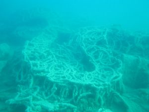
So, hostilities of this chapter of WWII started with the sinking of F495 “Naxos” Landing Craft. Little was known about this until was discovered and identified by local divers in 2007. It is severely damaged and rests in shallow waters of 9-15 m. The seabed composition is sea grass and sand with wreck debris scattered over a huge area approximately 250 long and 40 m wide, with fuel barrels, jerry cans, few motorcycles, vehicle spare parts, antisubmarine nets, artillery parts, ammunition and other cargo.

F-495 Naxos

Whilst most of the surrendered Italians were executed, an estimated 2-3000 according to  some sources, were to embarke in ships and taken in concentration camps. Some of them made it to their destinations and others drowned when the ships were sunk in various locations in the Adriatic, by the Allies. But the tragedy of the prisoners onboard SS Ardena was to take place before the eyes of the locals.

SS Ardena (HMS Peony)

Originally built for British Royal Navy in 1915 as HMS Peony, the vessel was a sloop minesweeper of Azalea-class. After WW I was acquired by London & South West Railway and later by Southern Railway, renamed SS Ardena and used on the routes of Southampton and Cherbourg/Caen until sold to on 1934 to Toyias Shipping Company in Piraeus, Greece.

During the days of German invasion in Greece, on April 6, 1941, was sunk by Luftwaffe in Piraeus but later raised and used by the German Navy. The final act came on September 28, 1943, when SS Ardena was sailing from the island of Kefalonia to the mainland Greece with some 840 Italian prisoners. At the exit of the bay of Argostoli probably hit an unmarked sea-mine of the minefield Italians have laid earlier and sank with great loss of life.

The vessel was in the middle of the shipping lanes and in water shallow enough for the masts to reaching the surface. Although being a war grave, in the grim years after the war, the top deck parts and superstructure were salvaged and what remains today is the bottom part of the keel, still keeping its ship line, along with scattered debris around at the seafloor, and at a depth of 29 m. The visibility on the site is often limited by currents stirring the sediment. However, divers visiting the site with the outmost respect, can see personal items such as boots, shaving razors, tin plates and flasks and sometimes even human remains. Every year on the day of the sinking, a ceremony is held by Italian and Greek officials. On 2009, Italian Navy divers laid on the site a commemorative plaque to the memory of the souls lost.

Divers bringing the commemorative plaque at SS Ardena

Roughly at the same time another boat was lost to enemy action just off the coast of Poros. On May 23, 1943, Captain Miltiadis Houmas, agent of the Greek branch of MI9, arrived in Poros, Kefalonia, with orders by Major Michael W.Parish to help John Capes, the sole survivor of HMS Perseus to escape, after spending 18 months in Axis occupied Kefalonia, hidden by the heroic locals. The above information as well as the following abstract is by Kostas Thoctarides book, who discovered the submarine wreck in 1997:
“At 13:30 in the afternoon, five English planes and one American, flying low, almost at sea level, made their appearance. A caique had left Zakynthos. Strafed from above, the caique caught fire. The Italians immediately came on board our caique and asked us to head for the wreck in order to collect the shipwreck survivor”.

150mm shells at the WWII wreck

As indicated by the recent research, this same caique wreck lies off shore Kapros Cape in Skala at a depth of 40 m. Divers approaching the wreck encounter a pile of war supplies in the shape of a vessel that its wooden parts have long rotted away, in a dive into history for WWII enthusiasts. A worth-reading extensive article with all recent findings and historical research can be found here:

https://www.bluemantadiving.gr/the-extraordinary-wwii-shipwreck-of-cape-kapros-in-kefalonia/

As Kefalonia was occupied by Axis forces during WWII providing harbour for their ships, there is no surprise that there were many Allied air raids around the island. Many Allied airplanes have shot and crashed around Kefalonia, some laying in extremely  deep waters and some awaiting to be discovered. One of them is rumored to lay in the bottom of Argostoli bay but has not been found yet.

On the north of the island, near Fiskardo, there is a known airplane crash site. A SAAF Bristol Beaufighter raiding Fiskardo harbour was shot by German anti-aircraft defences and crashed at Kimilia bay, having its navigator killed and the pilot surviving to be captured. After the war the plane was towed closer to the shore and salvaged due to its precious metals and nowadays few pieces remain scattered on the seabed and can be seen by divers, along with a commemorative plaque, at a depth of 8-10m.

A Bristol Beaufighter

Very little, if at all, is known for the wreckage of a Luftwaffe Ju 88 at the southeastern tip of Ithaca on the crest of a sloping reef that shortly reaches the contour line of 100 meters.

Ju 88 tail part

The aircraft met its fate as it ditched a short distance offshore reportedly hit by allied fire. It is shocking to imagine the force of the crash as the two engines can be found far apart at 22 and 28 meters of depth and the tail sits at 36m much further away. Probably parts of fuselage have rolled deep down the slope, off limits for recreational divers but pieces of the wings are found and positively identified around the top of the reef.

Luftwaffe Ju88 engine

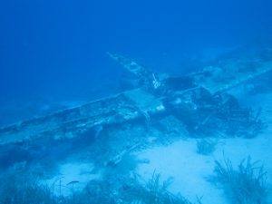
Beyond any doubt, the most known WWII wreck in Kefalonia and probably among the most known in the world is the British Overseas Patrol submarine HMS/M Perseus, (N36) that lies virtually intact on the sandy bottom, at 52 meters depth, about a mile off the south coast of Kefalonia. HMS Perseus was a Parthian class submarine built by Vickers-Armstrongs at Barrow in Furness in 1929.

HMS Perseus (N36)

Perseus submarine is perhaps the the top WW II wreck dive in Mediterraneanand probably the best submarine dive in the world but beyond being among the most impressive wreck dives a diver can experience, also has an amazing history as well. The vessel was on combat patrol in December 1941, and while cruising at the surface at night hit an Italian naval mine and sunk. From the crew of 59 only one, the Royal Navy leading stoker John Capes managed a daredevil escape from a depth no one has attempted before. In fact, during the whole of the war there were only four escapes from stricken British submarines. Capes swam his way to Katelios and with the aid of locals escaped capture from Italian and German occupation forces and finally transferred in Turkey. While legendary in Royal Navy, almost nobody believed his adventure until in 1997 the team of Greek diver and u/w explorer Kostas Thoctarides located the submarine and verified details of his described escape.

The divers approaching the submarine encounter a magnificent vessel 88 meters long, with a large conning tower, the ship’s gun and the rear hutch still open indicating the escape route of John Capes, while a look in the interior is possible. Among other things, the torpedo tubes and the ship’s propellers and rudder are visible, as well as the damage caused by the sea mine. The anchor of the mine still can be seen few meters from the aft of the submarine. Much is said about this magnificent wreck and its tragic story and more details on the story of John Capes can be found here:

https://www.bbc.com/news/magazine-15959067

These wrecks are just the few that lay in depths that can be accessed by divers and can fill many WWII history pages. But as monuments of wartime tragedies and war graves, should be treated with outmost respect. Just like the many more around Kefalonia, from both World Wars that lay in deep waters or still waiting to be discovered.


This article couldn’t be written without the research of

Kostas Thoctarides, Tilemanchos Beriatos and Steve Worthington


An unnoticed episode in the story of HMS Perseus British submarine

25 December 1997, Christmas Day. Under dusk, a boat silhouette begins to appear on the screen with the shape, length and volume of the boat that the team was looking for four three weeks in the heart of winter. The search of the seabed with a geophysical survey sounding system (SONAR) and an underwater camera had yielded the much expected results. The next day, the Greek explorer of the seas and experienced diver Kostas Thoctarides makes the first dive in the British submarine lost in World War II, forgotten for 56 years. The Royal Navy “HMS Perseus” was launched in 1929 and initially served in the Far East, but as Italy declared war in 1940, the submarine was transferred to Alexandria, Egypt, to reinforce the British fleet in the Mediterranean. After several patrols in the eastern Mediterranean, in November 1941 it left Malta for an offensive patrol in the Ionian Sea and on December 6 it crashed into a naval mine and sank just 2.5 nautical miles off the coast of Kefalonia. The story is well known from now on thanks to the team that located and identified the shipwreck and conducted an excellent historical research.

HMS Perseus (N36) conning tower

However, a small episode in the history of Perseus has gone unnoticed.

According to the historical information gathered by the team of Kostas Thoctarides, on Sunday 23 May 1943 at noon, the small fishing vessel “Evangelistria” with Captain Houmas from Samos island, member of the British organization MI9 operating in occupied Greece, Giannis Katsoulakis mechanic, Nikos Anagnostou sailor and Antonis Evangelatos liaison with the local resistance, arrives in Poros, Kefalonia, in order to evacuatethe only survivor of HMS Perseus submarine, John Capes. After a trip of about 450 nautical miles (800 Km) from Chios island, Captain Houmas records in his diary that about an hour and a half after their arrival, six allied warplanes strafed a boat that had departed from Zakynthos carrying oil and gasoline, which caught fire. The Italians ordered “Evangelistria” (which for this mission had been renamed “St. Nicholas”) to take them to the site, but after a deliberate delay a passing tug picked up the shipwrecked crew. And here begins the story of the findings of another shipwreck of World War II, which is probably the boat whose sinking is narrated by Captain Houmas and is so tragically connected to the “Perseus” as the two boats found their way to the seabed at the same turbulent period of history in the sea area southeast of Kefalonia.

 The shipwreck of a small boat off  Cape Kapros, near Skala town

At a distance of about 2 nautical miles south of Poros port on the route to Zakynthos, lies the wreck that has been known to local fishermen for years, but until now has not been identified and researched in detail (although included as a monument in the list compiled for the Ionian Aquarium-Museum set up in Kefalonia during the INTERREG IV Greece-Italy Program, 2007-2013).

Today, the timber hull parts with a complete lack of metal parts found at the site, suggests that it had been a small boat with wooden hull with a length of about 15 m and a width of about 4 m (since only).

More importantly, the vessel carried several dozen 0.70m long artillery projectiles caliber 150mm, one that according to available information, was appropriate only to the 3 (according to other sources 4) German coastal defense guns (in concrete cast emplacements along with underground tunnels for storage and barracks). These had been set up by the German command at Cape Dhafnoudhi in Erissos peninsula (northern Kefalonia), after the armistice of Italy and the local dominance over the Italian forces in Kefalonia in September 1943. It is noted that this coastal artillery position was covering the strait between Kefalonia and Lefkas islands (the coastal battery at Cape Munda covered the strait of Kefalonia-Zakynthos likewise).

The position of one of the guns in Dhafnoudhi-photo Tilemachos Beriatos

Model of a 150mm gun in miniature

One of the coastal guns emplacements in Dhafnoudhi (photo 1950-55)

Regarding the identification of the wreck, although a time mismatch is observed as the installation of the 150mm guns (it took place between September and October 1943) post-dates the sinking of the ship reported by Captain Houmas (May 1943), it is possible and very likely for the German command to have foreseen the collapse of the Italian ally and thus to provide for the transfer of the necessary materials, components and ammunition so that it is ready to take over the defense of the areas at both Capes (and other positions on the island) previously held by the Italians, without significant interruption. After all these bigger guns were simply an upgrade of the Italian 105 and 75 mm ones that were previously installed and perhaps this was a long-planned move to improve the island’s defenses.

The extraordinary boat’s cargo now lying on the seabed

It is established that many large or small vessels belonging to the local population were temporarily (or in other cases throughout the war) commandeered by the occupying forces to carry out various secondary missions, mainly in supporting roles (due to their insufficient capacity for warfarefront roles). One of these missions was to transport military supplies and troops. It is clear that the particular ship that sank off Cape Kapros was such a small boat that carried German-made ammunition and some medical supplies.

Apart from artillery projectiles, other components to this day lying on the seabed, although covered with marine growth, are artillery projectile fuses, mechanisms with a timer for controlled firing of explosive missiles either above the target or after penetrating inside the target ship.

150mm artillery shells at Kapros German WWII Wreck- photo Tilemachos Beriatos

Artillery projectile fuse WWII found in south Kefalonia- photo Tilemachos Beriatos

As for portable firearms, there are 7.92 mm cartridges (known as the “8mm Mauser training round”) used for MG34 or MG42 machine guns, since cycling the weapon required a specific minimum gas compression inside the barrel). Another possible use was launching rifle-grenades. Interestingly, their use against humans was prohibited by the Geneva Convention as it would lead to the penetration of wood fragments into the body.

8mm Mauser Training rounds -photo Tilemachos Beriatos

A very interesting finding is a small tube that according to the inscription “Körper-schuß-salbe” (in the Old High German language), which were quite difficult to read after decades of staying on the bottom of the sea, it contained a wound treatment ointment, possibly sulfanamide, which was used extensively until the middle of the Second World War, being the first effective antibiotic before penicillin which was used at the end of the war. Thanks to the rest of the inscription “Wehrkreissanitätspack VII” we know from what military district (support command) during the war, the specific object was distributed, with the one being “number 7” based in Munich.

German WWII sulfanamide tube-photo Tilemachos Beriatos

Military District n.7 based in Munich

Another finding is a small bakelite box containing 10 “Losantin” tablets (active ingredient Calcium Dihypochlorite) for skin disinfection to protect against mustard gas poisoning (after the experience of using gases in the First World War). Soldiers were instructed to keep these tablets (4 boxes) in their pockets at chest height, apparently to accommodate immediate access.

This particular shipwreck is very interesting, since it is probably connected with the escape story of the only survivor of submarine “HMS Perseus”, but also due to almost certainly being connected with the coastal defense battery installed on the island to defend not only the island itself but also the marine passages towards the mainland. Perhaps even more important is the fact that it highlights the coexistence of inhumane weapons of destruction, with humanitarian tools to care for the wounded, at the same historic site where now lies a small undisturbed time capsule, another monument to the greatest war Humanity ever witnessed. The same human hands that operated the guns that were taking lives, at the same time applied the medicines that saved them, much like two opposite views that are expressed in the same common dialogue of human history.

To this day, the monuments of this turbulent period of the war around our islands, are submerged in the deep waters of the Ionian Sea, keeping alive historical memory. They act as artificial reefs on the seabed – small cradles of life for marine species, but also exhibits of the unexplored vast museum of the ocean, the last great unknown on our planet.

Tilemachos Beriatos

CMAS 3-star diver

PSS Technical Diver


It is well known that Greek seas are full or ancient relics as for millennia daring sailors connected the civilizations around Mediterranean. Greeks established  sea commerce among their colonies from the coast of modern day Turkey and eastern Mediterranean and also Italy, Sicily and all the way to the far western end of Mediterranean to the  Greek mainland and islands  in a more complex and spread way than civilizations before them, making Greece the center of this commerce. And then there was the vast Roman empire spread all around Mediterranean that intensified marine commerce and traffic but once again Greece was in the center of these marine routes. Literally every island and all channels and straits in Greek seas are littered with ancient pottery that can be dated as from prehistoric times of 2700 BC to the late Roman times of 600 AD.

Such is the case at the sea around Kefalonia and Ithaca. Historical data and modern simulation models alike (like ORBIS by Stanford University) point out that the straits around the islands were a central transport hub for the marine commerce during Greek and Roman times. Back then sailing was made as close to the shore as possible, so an obvious way was to sail from island to island and around continental coastline. That marks the pivotal location of Kefalonia. Kefalonia stands at the exit of Gulf of Corinth so was in the way of all marine traffic from this city-state (a sea commerce giant in classical era) and from Athens as well towards the Greek colonies in Italy, Sicily and further, like modern day Marseille and more. That is also the case for ships coming from the rich cities of Aegean islands, Crete, Asia Minor, Syria, Palestine, Cyprus and Egypt. Even from these territories, sailing was made with small leaps from island to island and then around the coastline of Peloponnese and then depending on the destination, there was two, major, possible routes:

For vessels heading to Dalmatian and Adriatic coastline or to Eastern ports of Italy, the main route was the channel between Kefalonia (and the one between Ithaca and greek mainland to a lesser extend as slightly longer). For vessels heading to all of western Mediterranean ports and most importantly Sicily and Rome, the route was following the south coast of Kefalonia before the last perilous leap from the southwestern tip of the island towards Italy.

A clear evidence of this marine traffic lies in the bottom of the sea around the coastline of the islands. There are two main patterns. Bays and inlets that could offer protection from rough seas usually have evidence of wrecks at the headlands marking them as not all captains have managed to sail their ships into safety in bad weather. In these cases, the main patterns are small or massive piles of amphorae (depending on the size of the vessel) starting from the shallows at the coastal rocks and gliding down to the underwater slopes. Usually in this case metal parts, mostly copper and lead, of the sunk boats can be found like anchors, parts of the rigging, nails etc. Inside protected bays that ships were spending some time at anchor, one can find amphorae belonging to many different eras, as sailors were littering the bottom with the clay pots after consuming the content or getting rid of what was damaged. In these bays used for millennia, lost anchors or other items can also be found.

Following the traces in land and below the sea we can form an idea of what was happening then and especially in Roman times, when the marine traffic was intense within the vast empire and also trading posts and harbors were set in the land.In Kefalonia along these routes there is the ruins at Fiskardo which apparently was an important Roman harbor and of course the port of Sami, that after besieged by the Romans became their administration center on the island. And then there is evidence of a very important roman presence in Skala, where there are ruins of a residence complex with many rooms and amazing mosaics. Skala could be a significant outpost as Cape Mounda is the point that sailing to the western Mediterranean starts, following the south coast of Kefalonia.

Ancient wrecks of Kefalonia

A more detailed idea can be given when looking at the u/w evidence. There are lots of wrecks and temporary ports evidence along those marine routes, many within scuba diving or snorkeling limits and many more yet to be discovered.

Starting from Mazi cove at the southwestern tip of Ithaca, where a tiny bay protected from prevailing northern winds is, scattered amphorae can be found around, marking a final resting place and possibly freshwater fountain for the sailors before turning around the cove and sail through the channel. At Ithaca’s west coast also roman roof tiles and amphorae can be found in proximity to the modern ports of Pisaetos and Polis, cargos of long-gone boats.

Right across Mazi, on the east coast of Kefalonia and at the land head separating Antisamos bay from Sami there is what’s left from a roman boat that crashed to the rocks and sunk. Crumbles of amphorae stuck together in blocks lie at the coastal rock just few meters below the surface, whilst bigger parts of 2ndc BC amphorae litter the u/w slope.

Further north at the east coast of Kefalonia there is a wreck site of paramount importance.  The wreck there is dated back to Protohelladic Period(PH II-PH III, 2750-2000 B.C.) and obviously claims to be the oldest in the Mediterranean! The area is under archeological research and closed to recreational diving.

Gagiana Cove ancient greek wreck

A roman era wreck with few dozens of amphorae also can be found at the steep u/w slopes of the tiny islet Asteris, not too far from Fiskardo. Asteris is mentioned in Odyssey as the place where an ambush for Tilemachos was set. And then there is the huge roman wreck just of the bay of Fiskardo, a well-known wreck for some years now by the Ephorate of Underwater Antiquities, that recently hit the news worldwide as Greek scientists from the Laboratory Marine Geology & Physical Oceanography of Patras’ University published a paper about their survey on the site few years ago.  The wreck is in deep water and what makes it unique is that its obvious size and massive cargo challenges what was believed for the size of boats of that era. The cargo, literally a hill of around 5000 amphorae maintains the shape of a ship as the wood eventually disintegrated. The area is under archeological research and closed to diving, regardless if the depth is beyond the limits of recreational diving. Obviously there are many more wrecks to be discovered around the channel and towards Lefkas, but deep water still hold well the secrets of the past.

Fortunately, to the south of the island the coastal waters are much shallower and not only are a cradle of history but also reveal the relics. In Limenia beach between Poros and Skala even snorkelers can observe small fragments of pots, obviously broken and curved by the waves for centuries, and one can imagine small boats anchored and fishermen at rest, after having some wine, throwing the amphora in the sea, just like many modern day holiday makers!

The last bay north of Skala and before boats being exposed to south winds and swell, on both sides holds evidence of small late roman era wrecks, in the form of mostly broken amphora stuck together and elements of lead anchors, but also there are random period and shape amphorae and anchors here and there, obviously from boats seeking a temporary shelter.  Closer to Skala and below the land archeological site of the archaic temple, different era pieces of amphorae are scattered around the little bay, most probably from boats anchoring there for the sailors to visit the temple, or perhaps the bay was serving as a harbor for Skala.

And then there is the infamous Kakava Shoals, an extended shallow area a couple of miles off Cape Mounda. The shoals are dangerous to ships even in modern times so one could guess what a deadly surprise were the sharp rocks of the reefs whilst swept by swell for ancient sailors.  There the abundance of amphorae in some places is such that once was believed to be a legendary submerged village! In fact there are at least four different era ancient wrecks ranging from 5thBC to 5thAD centuries already identified at the shallower parts of the shoals and obviously many more to be discovered. Among the most peculiar findings is a site where 12 anchors, probably late roman type, are scattered, perhaps in an attempt to lighten and save a ship.

Roman merchant boat

Further down the south coast of Kefalonia there are two more landmarks that hold evidence of ancient marine routes, Dias and Agios Nicolas islets. Around Dias different era pieces of amphorae are scattered around, most probably from boats anchoring for the sailors to visit the temple of Zeus once there. At Agios Nikolaos sharp rocks, apparently a ship have crashed and crumbles of amphorae stuck together in blocks along with some bigger fragments lie just few meters below the surface. The final contact point with the land of Kefalonia before sailing at the open Ionian Sea towards Sicily and the west, is a little protected bay just before Cape Gerogombos at the southwestern tip of the island. There sailors could find fresh water and the last chance for some rest.  Amphorae and anchors of many shapes and periods from early Greek to late Roman times can be found there.

Underwater relics mark a marine flow that from southeast Kefalonia was diverted either north along the east coast towards the open sea beyond the strait between Kefalonia and Lefkas or westwards along the south coast and towards the open Adriatic Sea. Lots of archeological evidence prove Kefalonia as a key point of the ancient marine routes from the dawn of civilizations in the Mediterranean. And ancient Greeks were well aware of the geographical advantage of Kefalonia and Ithaca.

In the most well-known and influential epic poem of western culture, Homer’s Odyssey, the most legendary sailor of all times and probably the greatest explorer of Greek Mythology, Odysseus (Ulysses) is the king of Ithaca and Kefalonia and the ruler of “Magnanimous Cephalonians”!

All this underwater Archeological Heritage waits for scuba divers to discover!

On January 5, 2016, a fire destroyed two luxury yachts at the Marmaris Marina in Turkey. The news were with no significance to all but those familiar with the world and history of the Superyachts. These knew it was a real disaster: One of the two yachts destroyed was “The One”, that is considered probably the most beautiful Superyacht of all time, and beyond argument the one with the greatest influence on the design of these vessels. But in reality it was a reproduction of the original, and history could have been different, had it not been for a severe storm many years ago in southwestern Kefalonia! But let’s start from the beginning ..

This story begins in 1961 when Austrian billionaire Helmut Horten, passionate about sea and the yachts (when other tycoons of this era such as Aristolelis Onassis prioritized luxury), after owning Carinthia I and II earlier, had delivered from the French shipyard Chantiers Navals de l’Esterel the 25m Carinthia III, a classic yacht (as if starring in a James Bond movie!) that still sails in Greek seas under another name and owner. The 42 meter Carinthia IV from the same shipyard would follow, a beautiful and fast boat that would perished due to a fire in 1981 in Greece! These two yachts enhanced Horten’s desire for a unique boat, well ahead of its time. He trusted for the overall design the person that would influence the modern superyacht design more than any man, the legendary Jon Bannenberg!

Thousands of texts have been written and not only from nautical magazines, about this charismatic designer, called by Vanity Fair in 2018  “The Godfather of Modern Yacht Design”. For decades he was considered the most important designer of superyachts, being responsible for over 200 designs (including the Carinthias and his masterpiece Limitless which also belongs to the 10 most beautiful superyachts of all time ..). Bannenberg changed the world of mega yachts forever with his designs and influence. Until its time, yacht design was essentially a refinement and improvement of older models and an attempt to fit into the designs of the yachts the luxuries demanded by the owners as well as their ideas and expectations for the appearance of the boats. Ever since Horten commissioned Bannemberg to design Carinthia V, things would never be the same again!

Until the moment Bannenberg lifted the pencil to draw the lines of Carinthia V,yacht design did not really exist as a distinct occupation. Naval architects designed what they hoped were efficient and good-looking hulls and left the shipyard to complete the interior. Bannenberg made art his starting point, and sought to design every feature of a yacht from the exterior down to the doorknobs to achieve a completely consistent result. “Jon was building palaces,” said Dick van Lent of the Feadship Yard in the Netherlands. “Others were building boats.” Bannenberg himself put it less regally: “If you cannot make love in comfort on a boat that cost millions, what the hell is the point?” he told Vogue in 1970.

Horten wanted a much bigger fast yacht this time and went to Lürssen of Bremen shipyards, which at the time built mainly warships such as the 42 meter Jaguar Class patrol boats, capable of 40 knots. These were not planing hulls but slim, semi-displacement ones with high-powered diesel engines. It was no surprise, therefore, that the yacht Lürssen proposed was long and slim and looked rather like a fast warship. With a narrow beam, a lot of length was needed to provide enough accommodation space, and the overall length came to an impressive 68 meters. Bannenberg’s contribution was to integrate the whole design so that the drama of the long, slim hull was emphasized to the maximum. The sheer line runs the full length of the hull without interruption, and bow and stern slope forward to give an impression of urgency. The front of the superstructure is drawn as a sweeping curve. All the design elements of Carinthia V are simple and strong, and distracting details are avoided. Satellite domes, for instance, are placed well aft on an arch rather than on top of the wheelhouse or on the mast. As soon as you look at Carinthia, it is obvious that one hand has been responsible for the whole vessel from overall concept down to the smallest detail. Bannenberg was not given full responsibility for the interior because the owner’s wife, Heidi, favored using blond timbers and strongly colored rugs to create the Norwegian wood’ look that was popular at the time.

Carinthia V was a boat really coming out of a futuristic fairy tale: The most modern, fashionable and impressive of a line of yachts, owned by a yacht-passionate billionaire, designed perhaps by the greatest superyacht designer of all time, with a concept and lines unseen by yacht world until it launched, seen a beautiful boat with an interior that would embarrass Manhattan’s most chic penthouse! In a manner, one could say that Carinthia V was the Titanic of superyachts. In fact, its fate was similar and strange, though fortunately less tragic: on her maiden cruise in the Mediterranean encountered a severe thunderstorm near the southwestern coast of Kefalonia. Modern navigation aids were not available at that time, and bad weather wasn’t making things easier to navigate the boat with the  available maps safely around the infamous Kakava Shoals. Like countless other boats over the centuries, Carinthia V hit an uncharted reef and sank just off the coast of Skala Kefalonia, on November 1, 1971, fortunately without casualties.

Perhaps the most beautiful superyacht of all time, and arguably the most influential in naval design, is resting since on the Kefalonian seabed. Carithia V had come so close to perfection that when Horten called Bannenberg next morning he asked him to build exactly an identical replacement that would become Carinthia VI. The only change Bannemberg made was to increase the overall length by two meters and put in extra watertight bulkheads to prevent a recurrence of the sinking. Even to this detail the siblings Carinthia V and VI have almost a similar story to RMS Titanic and HMHS Britannic, that was slightly larger and with more watertight bulkheadsthan the tragically famous Titanic.So Carinthia VI was mend to steal the glory of V, but as it had a long career, immortalized the fame of its creators. The flames ended Carinthia’s VI career under the new name The One and one would say met the fate of Carinthia IV and V in the same corner of the Mediterranean. Since then, Carinthia V wreck, the last specimen of this naval era rests in the sea of Kefalonia.

Following down the shot line, eyes try to distinguish Carinthia’s silhouette in the endless blue. Astonishingly, the 70 m vessel blends very efficiency with the seabed! However,  soon the elegant, slim lines of the vessel make their appearance and the sense of awe and admiration cannot be easily described. Unfortunately the vessel is turned upside down. The elegant superstructure has been crushed under the weight of the hull but much of it can be seen on the right side, with the typical “grille” of the frond lounge visible. Same thing for the speedboat that was nested on the upper aft deck. The rudders of the boat as well as the propeller, although partially covered with nets, bare the signs of impact to the reefs of the area. The devastating impact to the reef along the hull that the blow that caused the sinking can be seen. Moving on to the bow it is amazing how “sharp” the bottom of the hull looks but also the excellent condition of the wreck considering it spent nearly 50 years at the bottom of the sea. A huge spiny starfish (Marthasterias glacialis) is next to one of the bow thrusters close to the stem that descents at a sharp angle to the bottom ten meters deeper.

Limited bottom time at this depth brings dive to an end. Reaching the shot line we take another look at this historic shipwreck before we start ascent and switching gasses. We did carry only a small action camera as the main objective was to investigate the wreck so photos are not that good. However the entire Blue Manta Diving Team is looking forward to the next visit to explore of this magnificent shipwreck with the impressive story that rests in the blue waters of Kefalonia.

Mediterranean Parrotfish ((Sparisoma cretense) loves the shallow reefs and rocky shores with warm waters. Therefore is quite rare or absent in the northwestern Mediterranean and in the Adriatic Sea, but probably due to global warming there is an ongoing northward range expansion. In the Aegean Sea was even pictured in wall paintings since ancient years. And nowadays is joyful and abundant inhabitant oft the Ionian Sea. Their primary habitat is rocky reefs,  but they may visit adjacent Posidonia oceania  seagrass patches. Parrotfish feeding on epilithic and coralline algae and also on epiphytic algae, growing on seagrass. Constantly they chew the algae off  the rocks with their sharp teeth that look like a parrot’s beak and in a manner they shape the Mediterranean rocky reefs, like their tropical cousins do with the coral reefs. So  not just a nice face but also among the  most important species on the Mediterranean reef, as they are the “doctors” eating expanding and dead epilithic algae and dead and keeping the reef healthy, constantly creating new inhabitant for all species to play their role and complete their life circle in the bottom of our seas.

Because of the their mouth and teeth parrotfish is funny looking but also is a graceful, constantly moving swimmer  at the same time, one very challenging to capture on a photo, unless the perfect focus is not an issue.. And while the bright and colorful females are  red with a yellow-edged grey saddle shape on the back and a yellow spot at the base of the tail, males are overall grey with paler underparts and no distinctive markings. It is quite easy for the divers to distinguish them, especially as they form small or large groups, where one large male dominates the females. The same male was a female earlier in its life that, as in many fish species and as growing bigger changed into a male.

A huge school of male Parrotfish (Sparisoma cretense)

Probably not all females grow into males but there should be many. Otherwise how one can explain the u/w marvel experienced for few weeks roughly the same time every year, in the heart of the summer-usually in August- at the shallow reefs around Skala Kefalonia? Divers may experience schools of male parrotfish more than 300 strong, foraging the reef and making mad the local males that are trying to defend their territory in their pale-grey war colors! These schools are totally focused on plundering the reef and ignore the divers allowing them to come close to observe or take u/w photos.

Diver among parrotfish

This is a unique behavior that hasn’t been officially recorded and studied yet. But still there for lucky divers to experience the u/w wonder of the “buccaneer” parrotfish!


One could claim that Fangtooth Moray (scientific name: “Enchelycore anatina”) is among the most terrifying looking marine animals in the Mediterranean . That is probably due to its elongated jaws and especially the teeth, which have a crystal, glasslike appearance and are visible through the curved jaws even when the mouth is closed. The black and yellow stripes and dots on its body add to the impression and is also known as Tiger Moray – although its basic color pattern mostly resembles a leopard!

Morays are infamous for having strong jaws and powerful bite. However, this fella attacks only when feeling threatened, so unless divers put hands in cavities in or between the rocks while exploring the bottom, they are safe. Generally, it does not behave aggressive at all (and definitely not to u/w photographers!).

Fangtooth Moray is a migrant species into the Mediterranean from the Atlantic Ocean , and here found a supplementary role to the more common Moray Eel in the ecosystem. Most people cannot even distinguish it is a different species. It is a solitary creature and usually spends the day between the rocks of the bottom while hunting mostly at night. It feeds on small fish, crustaceans, cephalopods (especially favors octopus!), and dead animals.

As not a significant commercial species, Fangtooth Moray is not targeted or threatened by overfishing. However, it is a usual by-catch to long fishing lines, nets and trawlers. It also suffers to the loss of habitant, the decrease in populations of species that is preying on and also to general deterioration of u/w environment. Fangtooth Moray is not abundant and is not studied enough but as predator is playing a key role in the fragile marine ecosystem. Not many, not even most divers are aware of its presence in the Mediterranean. Raising awareness for this colorful creature may grant it an opportunity to stay safe in Mediterranean Sea for the future.


Triton’s Trumpet, also know as Giant Triton or “Bourou” in Greek, (scientific name: “Charonia tritonis”), is a mollusk gastropod, a sea shell, practically a snail of impressive size. It is the biggest and most known sea snail of the Mediterranean. Different species of this genus are found in temperate and tropical climatic zones all over the world, while the size of larger ones can reach or even exceed half a meter in length. It is usually in the shade of the rocks or in holes where it passes the day waiting for the arrival of darkness, when it is time for most fish to go for rest and for night predators to prey.
The seemingly harmless Triton is a carnivorous animal, a predator of the bottom, who feeds on other mollusks and starfish. Something that one wouldn’t expect from such a creature is that when Triton detects the smell of the prey, starts chasing it. Although the pursuit is far from a cinematic version of dizzying speed, it is just enough to be quicker than your prey, and Triton does!
Triton apparently has a particular preference on starfish and after catching them, opens a hole in their hard skin with a radula tooth (imagine a can opener), and then injects its nerve paralysing saliva. Despite eating poisonous thorns or other unwanted parts of the prey, Triton manages to spit these out. Triton is a very important predator for marine ecosystems as regulates the population of starfish and echinoderms that otherwise would devastate corals and u/w flora.

Someone somewhere once tried to blow through a small hole that could have been created when the edge of the Triton’s shell broke, (and could that led to the invention or inspiration for the construction of a trumpet music instrument?). The Triton has been used since antiquity to create this distinct sound,  especially by sailors, giving the shell its Greek name. The god Poseidon, but especially its son Triton – the messenger of the sea in Greek mythology, are often depicted holding such a shell and ruled the waves with it. This obviously inspired the English common name “Triton’s trumpet”.

Nowadays, Tritons are at risk due to lost of habitat, depletion of then ecosystem and quite often becoming a by-catch or picked for their shell, although is endangered and protected.

“The shadow of the seas”

This is  “Sikios” or “Pantelis” in Greek, the Brown Meagre (or Corb- scientific name: “Sciaena umbra”). This species spreads in the Mediterranean Sea, the Black Sea and the East Atlantic. It is usually found in rocky and sandy sea bottoms with seagrass  meadows (in fact, the iconic”Posidonia oceanica” seagrass which is not an algae but a plant) in depths from 5 to 200 meters and is preying on small fish and crustaceans (crabs, shrimp etc.). A good-looking phantom!

Sikios is an amazingly beautiful fish of the Mediterranean, with golden and silver flashes in its body and impressively bright dorsal and caudal fins – yellow with black edges and white details, while its movement is full of grace. It is mainly nocturnal fish that can be seen during the day although it prefers to remain in the holes of the rocks.

The second composer of its Latin name  “umbra” means “shadow,” and is inspired by his ability to remain invisible- partly due to the colors of his body, and partly to the perfect buoyancy he can achieve by staying motionless in shadows in the depth of the cavities where is hiding.  The fish of this species (croakers) have two bone “hammers” in their head (called “otolithi”) with which they create sounds to communicate, especially as they are very sociable and live in small groups.  If keep quite silent and can approach such a “shadow”, a diver can distinguish the special sounds, as long as he is not to late for the show!