Tag Archive for: diving

It is well known that Greek seas are full or ancient relics as for millennia daring sailors connected the civilizations around Mediterranean. Greeks established  sea commerce among their colonies from the coast of modern day Turkey and eastern Mediterranean and also Italy, Sicily and all the way to the far western end of Mediterranean to the  Greek mainland and islands  in a more complex and spread way than civilizations before them, making Greece the center of this commerce. And then there was the vast Roman empire spread all around Mediterranean that intensified marine commerce and traffic but once again Greece was in the center of these marine routes. Literally every island and all channels and straits in Greek seas are littered with ancient pottery that can be dated as from prehistoric times of 2700 BC to the late Roman times of 600 AD.

Such is the case at the sea around Kefalonia and Ithaca. Historical data and modern simulation models alike (like ORBIS by Stanford University) point out that the straits around the islands were a central transport hub for the marine commerce during Greek and Roman times. Back then sailing was made as close to the shore as possible, so an obvious way was to sail from island to island and around continental coastline. That marks the pivotal location of Kefalonia. Kefalonia stands at the exit of Gulf of Corinth so was in the way of all marine traffic from this city-state (a sea commerce giant in classical era) and from Athens as well towards the Greek colonies in Italy, Sicily and further, like modern day Marseille and more. That is also the case for ships coming from the rich cities of Aegean islands, Crete, Asia Minor, Syria, Palestine, Cyprus and Egypt. Even from these territories, sailing was made with small leaps from island to island and then around the coastline of Peloponnese and then depending on the destination, there was two, major, possible routes:

For vessels heading to Dalmatian and Adriatic coastline or to Eastern ports of Italy, the main route was the channel between Kefalonia (and the one between Ithaca and greek mainland to a lesser extend as slightly longer). For vessels heading to all of western Mediterranean ports and most importantly Sicily and Rome, the route was following the south coast of Kefalonia before the last perilous leap from the southwestern tip of the island towards Italy.

A clear evidence of this marine traffic lies in the bottom of the sea around the coastline of the islands. There are two main patterns. Bays and inlets that could offer protection from rough seas usually have evidence of wrecks at the headlands marking them as not all captains have managed to sail their ships into safety in bad weather. In these cases, the main patterns are small or massive piles of amphorae (depending on the size of the vessel) starting from the shallows at the coastal rocks and gliding down to the underwater slopes. Usually in this case metal parts, mostly copper and lead, of the sunk boats can be found like anchors, parts of the rigging, nails etc. Inside protected bays that ships were spending some time at anchor, one can find amphorae belonging to many different eras, as sailors were littering the bottom with the clay pots after consuming the content or getting rid of what was damaged. In these bays used for millennia, lost anchors or other items can also be found.

Following the traces in land and below the sea we can form an idea of what was happening then and especially in Roman times, when the marine traffic was intense within the vast empire and also trading posts and harbors were set in the land.In Kefalonia along these routes there is the ruins at Fiskardo which apparently was an important Roman harbor and of course the port of Sami, that after besieged by the Romans became their administration center on the island. And then there is evidence of a very important roman presence in Skala, where there are ruins of a residence complex with many rooms and amazing mosaics. Skala could be a significant outpost as Cape Mounda is the point that sailing to the western Mediterranean starts, following the south coast of Kefalonia.

Ancient wrecks of Kefalonia

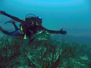
A more detailed idea can be given when looking at the u/w evidence. There are lots of wrecks and temporary ports evidence along those marine routes, many within scuba diving or snorkeling limits and many more yet to be discovered.

Starting from Mazi cove at the southwestern tip of Ithaca, where a tiny bay protected from prevailing northern winds is, scattered amphorae can be found around, marking a final resting place and possibly freshwater fountain for the sailors before turning around the cove and sail through the channel. At Ithaca’s west coast also roman roof tiles and amphorae can be found in proximity to the modern ports of Pisaetos and Polis, cargos of long-gone boats.

Right across Mazi, on the east coast of Kefalonia and at the land head separating Antisamos bay from Sami there is what’s left from a roman boat that crashed to the rocks and sunk. Crumbles of amphorae stuck together in blocks lie at the coastal rock just few meters below the surface, whilst bigger parts of 2ndc BC amphorae litter the u/w slope.

Further north at the east coast of Kefalonia there is a wreck site of paramount importance.  The wreck there is dated back to Protohelladic Period(PH II-PH III, 2750-2000 B.C.) and obviously claims to be the oldest in the Mediterranean! The area is under archeological research and closed to recreational diving.

Gagiana Cove ancient greek wreck

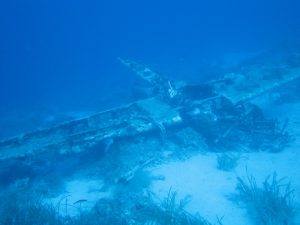
A roman era wreck with few dozens of amphorae also can be found at the steep u/w slopes of the tiny islet Asteris, not too far from Fiskardo. Asteris is mentioned in Odyssey as the place where an ambush for Tilemachos was set. And then there is the huge roman wreck just of the bay of Fiskardo, a well-known wreck for some years now by the Ephorate of Underwater Antiquities, that recently hit the news worldwide as Greek scientists from the Laboratory Marine Geology & Physical Oceanography of Patras’ University published a paper about their survey on the site few years ago.  The wreck is in deep water and what makes it unique is that its obvious size and massive cargo challenges what was believed for the size of boats of that era. The cargo, literally a hill of around 5000 amphorae maintains the shape of a ship as the wood eventually disintegrated. The area is under archeological research and closed to diving, regardless if the depth is beyond the limits of recreational diving. Obviously there are many more wrecks to be discovered around the channel and towards Lefkas, but deep water still hold well the secrets of the past.

Fortunately, to the south of the island the coastal waters are much shallower and not only are a cradle of history but also reveal the relics. In Limenia beach between Poros and Skala even snorkelers can observe small fragments of pots, obviously broken and curved by the waves for centuries, and one can imagine small boats anchored and fishermen at rest, after having some wine, throwing the amphora in the sea, just like many modern day holiday makers!

The last bay north of Skala and before boats being exposed to south winds and swell, on both sides holds evidence of small late roman era wrecks, in the form of mostly broken amphora stuck together and elements of lead anchors, but also there are random period and shape amphorae and anchors here and there, obviously from boats seeking a temporary shelter.  Closer to Skala and below the land archeological site of the archaic temple, different era pieces of amphorae are scattered around the little bay, most probably from boats anchoring there for the sailors to visit the temple, or perhaps the bay was serving as a harbor for Skala.

And then there is the infamous Kakava Shoals, an extended shallow area a couple of miles off Cape Mounda. The shoals are dangerous to ships even in modern times so one could guess what a deadly surprise were the sharp rocks of the reefs whilst swept by swell for ancient sailors.  There the abundance of amphorae in some places is such that once was believed to be a legendary submerged village! In fact there are at least four different era ancient wrecks ranging from 5thBC to 5thAD centuries already identified at the shallower parts of the shoals and obviously many more to be discovered. Among the most peculiar findings is a site where 12 anchors, probably late roman type, are scattered, perhaps in an attempt to lighten and save a ship.

Roman merchant boat

Further down the south coast of Kefalonia there are two more landmarks that hold evidence of ancient marine routes, Dias and Agios Nicolas islets. Around Dias different era pieces of amphorae are scattered around, most probably from boats anchoring for the sailors to visit the temple of Zeus once there. At Agios Nikolaos sharp rocks, apparently a ship have crashed and crumbles of amphorae stuck together in blocks along with some bigger fragments lie just few meters below the surface. The final contact point with the land of Kefalonia before sailing at the open Ionian Sea towards Sicily and the west, is a little protected bay just before Cape Gerogombos at the southwestern tip of the island. There sailors could find fresh water and the last chance for some rest.  Amphorae and anchors of many shapes and periods from early Greek to late Roman times can be found there.

Underwater relics mark a marine flow that from southeast Kefalonia was diverted either north along the east coast towards the open sea beyond the strait between Kefalonia and Lefkas or westwards along the south coast and towards the open Adriatic Sea. Lots of archeological evidence prove Kefalonia as a key point of the ancient marine routes from the dawn of civilizations in the Mediterranean. And ancient Greeks were well aware of the geographical advantage of Kefalonia and Ithaca.

In the most well-known and influential epic poem of western culture, Homer’s Odyssey, the most legendary sailor of all times and probably the greatest explorer of Greek Mythology, Odysseus (Ulysses) is the king of Ithaca and Kefalonia and the ruler of “Magnanimous Cephalonians”!

All this underwater Archeological Heritage waits for scuba divers to discover!

Perhaps the top WW II wreck dive in Mediterranean, British Overseas Patrol submarine HMS/M Perseus, (N36) lies virtually intact on the sandy bottom, at 52 meters depth, about a mile off the south coast of Kefalonia.

Perseus submarine is not only among the most impressive wreck dives a diver can experience, but has an amazing history as well. The vessel was on combat patrol in December 1941, and while cruising at the surface at night hit an Italian naval mine and sunk. From the crew of 59 only one, the Royal Navy leading stoker John Capes managed a daredevil escape from a depth no one has attempted before, swam his way to Katelios and with the aid of locals escaped capture from Italian and German occupation forces and finally transferred in Turkey. While legendary in Royal Navy, almost nobody believed his adventure until in 1997 a team of Greek divers located the submarine and verified details of his described escape.

The divers approaching the submarine encounter a magnificent vessel 88 meters long, with a large conning tower, the ship’s gun and the rear hutch still open indicating the escape route of John Capes, while a look in the interior is possible. Among other things, the torpedo tubes and the ship’s propellers and rudder are visible.

The submarine is practically an artificial reef and colorful sponges, big groupers, small fish and aquatic creatures take shelter here, while predators like amberjacks and snappers are frequent visitors.

Dive starts at the shot line that leads close to the conning tower and at around 25m depth the submarine is already visible. Leaving the shot line at around 35 m, and heading towards the bow, swimming at the side of the vessel and at a depth of 45 m, divers can see the devastating blow of the mine at port side and then the bow torpedo tubes, where at a depth of 48 m, Mark VIII torpedoes are ready to fire in their open tubes. On the way back towards the aft, divers overfly the wreck at around 44 m, observing hatches, winches and looking for groupers hiding within openings of the vessel, eventually reach the 4,9” gun and then the conning tower with the main hatch, periscopes and antenna. Further towards the aft, there is the still open escape hatch, that allows a look to the interior and the items inside, such as crates, machinery and even boots of the crew. Divers reaching the aft can see at a close distance the concrete anchorage of the sea mine and even descend bellow 45 m for a closer look to the rudders and propellers, where massive groupers, snappers and lobsters can also be found. The dive comes to an end heading smoothly towards the conning tower, where amberjacks usually prey on the schools of damselfish, to find the shot line and initiate the ascend and decompression stops.

The average depth or the dive is 40 m, while the max is 50, reserving the submarine for experienced and technical divers. The visibility is usually greater than 25m while temperature ranges between 18-24 C in summer months, depending on depth. Occasionally there may be strong currents close to the surface. Boat ride duration 15′.

Scuba Diving Kefalonia, Scuba Kefalonia


Infamous “Kakava” shoals are also an extended ancient wrecks site, once believed to be a submerged village. There is an abundance of amphorae, primarily from Roman era wrecks with at least one from 2nd century BC. Around the reef more evidence of ancient to modern day wrecks are present, such as steel ship parts and huge coal pieces, marking the resting place of an unknown steamboat.

The dive site is situated between the two main nesting beaches for Loggerhead sea turtles around Kefalonia “Kaminia” and “Skala”, so chances to catch sight of one looking for her next meal, are quite high.

Dive starts at the flat top of the shoal at 5m that could be the archetype of Mediterranean reef, with black and green sponges, brown seaweed and large schools of parrotfish and cow breams. Descending to the deepest part down to 12m, scattered pieces and blocks of smashed amphorae and metal relics from the ancient wreck become more and more abundant and among them brown meagres, groupers, scorpionfish and octopuses occupy every recess and crevice. Eventually coal pieces and metal remains mark the path towards the resting place of the unknown shipwreck and soon after divers reach the top of the reef where the ancient wreck crashed, and most intact amphorae can be found. Here, schools of damselfish hover against the current attracting predators such as snappers, Mediterranean barracudas and amberjacks. The return route to the boat is through peculiar rock formations, leftovers form the fragile rocky plate curved by forces of nature, and home to diverse marine life.

The average depth or the dive is 8 m, while the max is 12 m, appropriate for divers of all levels.

The usual visibility is 25 m and temperature ranges between 22-27 °C in summer months. Occasionally a weak surface current may be encountered. Boat ride duration 6′.


Scuba Diving Kefalonia, Scuba Kefalonia


Out of the Neptune’s seagrass meadows (“Posidonia oceanica”) a lone reef rises, a death trap to ancient vessels passing through the area. At least 2 of those wooden merchant ships once roaming the Mediterranean, have found their final resting place here, scattering their ballast stones, lead and bronze parts of their hull and rigging and scores of amphorae – their primary cargo, proving the area a puzzle to seamen through the ages.

On the underside of a long shallow rocky ridge, a small yet impressive underwater cave awaits to be explored. The dark chamber in the rock features two side-openings and one on the top acting as a skylight shedding ample light into the interior, rewarding the daring diver with spectacular views. Also a variety of fish and quite often

Dive starts on a sand patch at 7 m where wood parts of a sank fishing boat can be found and continues to the rocky ridge, with seagrass meadows on both sides, with schools of damselfish hover against the current attracting predators such as snappers and amberjacks. Soon the first and oldest wreck remains of many types and sizes of amphorae can be found, all the way to the entrance of the small cave.

Continuing along the rocky ridge at same depths, schools of parrotfish and cow breams are everywhere and a bit further down a massive stock of a stone anchor can be found, being the turning point towards the amphorae and metal relics of the second ancient wreck. A short cross over sandy and seagrass patches gives the chance to see all kinds of wrasses and perhaps Loggerhead sea turtles that are frequent visitors to the site and leads to a second rocky ridge where at its side the deepest part of the dive and usually schools of saddled breams along with groupers and morays can be found. Route along this ridge also leads back to the boat.

The average depth or the dive is 7 m, while the max is 12 m, appropriate for divers of all levels.

The usual visibility is 25 m and temperature ranges between 22-27 °C in summer months. Occasionally a weak surface current may be encountered. Boat ride duration 5′.

Scuba Diving Kefalonia, Scuba Kefalonia

There is no better spot for macro photographers to capture all the amazing micro flora and fauna of the Mediterranean. On the under-the-surface portion of the cliff walls, in the crevices and caves and within the same small extent of rock face, pseudo corals and all species of Mediterranean sponges can be found in a distracting variety and abundance.To add to the excitement, an old fishing boat wreck on the seagrass awaits divers to explore it! All together they create an ideal habitat for nudibranchs, moray eels, scorpion fish, blennies, gobies, wrasses, starfish and many more. Divers return again and again to capture colorful images one can hardly believe that belong in the Mediterranean .

Dive starts next to the rocky shore where a plateau at 5-6 m depth tops the walls bellow and follows a smooth slope descending to 16 m for a short cross over the Neptune’s seagrass that leads to the fishing boat wreck at 21 m. Among its remains and rusty pipes, nudibranchs, moray eels and octopuses can be found with snappers and amberjacks often visiting the area.  Upon return to the wall, the most impressively colored false corals, an abundance of sponges, ambushing morays, shy cardinal fish and graceful nudibranch occupy ever rock and crevice. Also, groupers, Triton’s trumpets and slipper lobsters are anything but a rare sight at the right time. The return starts with a smooth ascend to the edge of the wall, at 8-9 m depth, through schools of damselfish and cow breams, looking for more morays, and invasive, yet beautiful, lionfish and dive concludes with a safety stop on top of the plateau.

The average depth of the dive is 9 m, while the max is 21 m, appropriate for divers of all levels.

The usual visibility is 25 m and temperature ranges between 24-26 °C in summer months. Usually no surface currents are present. Boat ride duration 5′.


Scuba Diving Kefalonia, Scuba Kefalonia

Around Cape Kapros, the northern tip of Skala’s coastline, the cool water current from Kefalonia -Ithaca channel creates the perfect hunting grounds for Mediterranean predatory fish.
The water movement and the occasional currents around the cape is as intriguing, and create the perfect habitat both for bottom species like groupers, wrasses, breams, but also for blue water feeders like shoals of bogues and damselfish that feed against the current, just above the noticeable thermocline and their predators like dentex, blue runners, barracudas and amberjacks. The cape has probably a turbulent past, as ancient merchant vessel anchors and broken amphorae lay scattered around.

Dive starts at 5 m and follows a smooth slope down to 16m where the first pieces of amphorae can be found, continuing to some rocks at 21 m, a favorite spot of white groupers and morays and even more and diverse amphorae. Following the bottom of the rocky slope, it is a great inhabitant of dusky and gold blotch groupers, whilst bogues and damselfish feeding against the current, attract preying dentex and, barracudas. More intriguing amphorae and ancient anchors can be found before return starts with an ascend at the mid of the slope at 10 m. Along this depth there are rocks that give shelter to morays and nudibranch and to schools of bright red cardinal fish and their predators, the invasive lionfish. Along this course, there is evidence of a small ancient boat wreck, as crashed amphorae and metal relics can be found. The way back towards the safety stop spot is through large schools of cow breams and graceful damselfish.
The average depth of the dive is 12 m, while the max is 32 m, appropriate for divers of all levels.

The usual visibility is 25 m and temperature ranges between 19-25 °C in summer months. Occasionally a moderate surface current may be encountered. Boat ride duration 7′.


Scuba Diving Kefalonia, Scuba Kefalonia


Located at the northern extents of the Kakava reefs, this site is the most representative example of Mediterranean seafloor landscape and biodiversity in shallow coastal waters and provides excellent chances for u/w photographers. Collapsed caves and holes, along with meadows of Posidonia sea grass create the perfect environment for parrotfish, wrasses, gilt head breams, scorpion fish, young groupers and snappers. Around the reef fragments of ancient clay jars (“amphoras”) can be spotted, however the highlight of the site are the 12 enormous, probably Byzantine era anchors, presumably ditched by a ship struggling to escape crashing on the reef.

The average depth of the dive is 7 m, while the max is 12 m, suitable for divers of all levels.

The usual visibility is 25 m and temperature ranges between 22-27 °C in summer months. Occasionally a moderate surface current may be encountered. Boat ride duration 5′.


At the northern end of Skala beach, the rocky coastline provides an u/w landscape of walls and rockslides, which create an ideal habitat for most Mediterranean species. In this dive site, marked by the Cape Kapros lighthouse, boulders scattered among Posidonia seagrass provide a haven for all kinds of breams, wrasses, brown meagres and octopuses, especially when water temperature is below 23 °C, up to the end of June and again from early September. Huge schools of juvenile saddled sea breams and damselfish, along with often passing Loggerheard sea turtles, create scenery so rich that rarely can be matched by Mediterranean waters.

The average depth of the dive is 8 m, while the max is 17 m, appropriate for divers of all levels.

The usual visibility is 25 m and temperature ranges between 24-26 °C in summer months. Occasionally a weak surface current may be encountered. Boat ride duration 5′.


The rough, rocky scenery above the surface concludes in an equally impressive wall at the tip of the cove. Divers can observe remains of an ancient, roman era wreck that stretches across the levels of the dive. Fragments of broken amphorae but also an intact one, a lead stock of a composite anchor and ballast stones mark the final resting place of the long gone vessel. The reef is abundant with most species of Mediterranean aquatic life while Loggerhead sea turtles are anything but a rare sight.

Dive starts at 9 m on top a rocky plateau that descends smoothly to the bottom of the rocky slope. The Neptune’s seagrass at the side of the open sea meets the rocky coastline at a depth of 18 m, creating the perfect habitant for dusky and white groupers, white sea breams and brown meagres. Continuing further to the wall, crevices give shelter to more groupers, morays, scorpion and cardinal fish. The way back starts where the wall ends giving space to more seagrass and is exactly where gold blotch groupers find the perfect hunting grounds, often accompanied by snappers and upon return divers explore the shallower parts of the wall, at around 12m, where morays, invasive yet impressive lionfish, tube worms, wrasses and quite often slipper lobsters and Triton’s trumpet shells can be found. Where the wall ends into a rocky plateau, divers pass through schools of dancing damselfish and continue towards the amphorae and anchor of the ancient wreck laying at a depth of 9 m and just below the safety stop spot.

The average depth or the dive is 16 m, while the max is 31 m, appropriate for divers of all levels. Boat ride duration 9′.


OLYMPUS DIGITAL CAMERA DSC01962

At the easternmost tip of Ithaca, on the crest of a sloping reef that shortly reaches the contour line of 100 meters, lay the remains of a Luftwaffe Ju88 twin-engine bomber. The aircraft met its fate as it ditched a short distance offshore reportedly hit by allied fire.

Dive starts at the shot line on top of the reef at 12 m following the slope to the first Jumo 211 engine. It is shocking to imagine the force of the crash as the two engines can be found far apart at 22 and 28 meters and further away the tail sitting at 36m. On the steep slope bellow, aluminum remains indicate the path of fuselage and the wings drifting towards the abyss, undiscovered by divers so far. Apart from the aircraft remains, divers have the chance to explore the magnificent reef where large predators such as amberjacks and dentex and even dolphins or tunas occasionally, feed on the clouds of sardines and damselfish, while on the sides of the reef agile mottled groupers ambush to chase their prey. On the way back, divers can find many more, smaller scattered pieces of the aircraft, such as the standard twin machine gun and discover slipper lobsters and morays hiding in the crevices of the reef. Heading to the shot line to initiate the ascend and safety stops, the seagrass meadows bellow may grant the chance of seeing schools of barracudas. Quite often divers can catch the currents into a drift dive.

The average depth or the dive is 20 m, while the max is 37, reserving the site for experienced divers. The visibility is usually greater than 20m while temperature ranges between 18-26 C in summer months, depending on depth. Occasionally there may be strong currents close to the surface. Boat ride duration 35′.

IMG_0813 IMG_0818 IMG_0994 Lardigos 4-7-11 DSC02975+